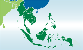
IWMI-Giriraj Amarnath, 'Monthly maximum flood inundation extent derived using MODIS 8-day 500m surface reflectance data for South East Asia (2006-Jul)', IWMI-Giriraj Amarnath, 2015
Sijmons K, Kiplimo J, Förch W, Thornton PK, Radeny M, Kinyangi J. 2013. CCAFS site atlas – Albertine Rift / Hoima. CCAFS Site Atlas Series. Copenhagen, Denmark: The CGIAR Research Program on Climate Change, Agriculture and Food Security (CCAFS).
IWMI-Giriraj Amarnath, 'Maximum flood inundation extent derived using MODIS 8-day 500m surface reflectance data for South East Asia (2000145)', IWMI-Giriraj Amarnath, 2015
IWMI-Giriraj Amarnath, 'Maximum flood inundation extent derived using MODIS 8-day 500m surface reflectance data for South East Asia (2001025)', IWMI-Giriraj Amarnath, 2015
IWMI-Giriraj Amarnath, 'Maximum flood inundation extent derived using MODIS 8-day 500m surface reflectance data for South East Asia (2002217)', IWMI-Giriraj Amarnath, 2015
IWMI-Giriraj Amarnath, 'Maximum flood inundation extent derived using MODIS 8-day 500m surface reflectance data for South East Asia (2006209)', IWMI-Giriraj Amarnath, 2015
IWMI-Giriraj Amarnath, 'Maximum flood inundation extent derived using MODIS 8-day 500m surface reflectance data for South East Asia (2008185)', IWMI-Giriraj Amarnath, 2015