Crops and technologies On crops, livestock, fisheries, irrigation, technologies, production and more.
Landscapes and biodiversity On land, landscapes, forests and forestry, biodiversity, ecosystems, ecology and more.
Nutrition and health On nutrition, malnutrition and overnutrition as well as health, diets, diseases and more.
Social Inclusion On inclusion, social classes, social groups, social participation, social protection, Indigenous peoples and more.
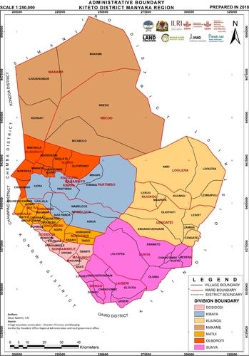
Map Administrative boundary Kiteto District, Manyara Region Kalenzi, D. 2018. Administrative boundary Kiteto District, Manyara Region. Nairobi, Kenya: ILRI.
Map Potential Natural Vegetation Map of Eastern Africa (Burundi, Ethiopia, Kenya Malawi, Rwanda, Tanzania, Uganda and Zambia) Version 2.0 van Breugel P et al., 'Potential Natural Vegetation Map of Eastern Africa (Burundi, Ethiopia, Kenya Malawi, Rwanda, Tanzania, Uganda and Zambia) Version 2.0', 2015
Map Crop yield of irrigated areas in 2008 Chandrashekhar Biradar, Layal Atassi. (31/10/2017). Crop yield of irrigated areas in 2008
Map Actual Evapotranspiration of irrigated areas in 2002 Chandrashekhar Biradar, Layal Atassi. (31/10/2017). Actual Evapotranspiration of irrigated areas in 2002