IWMI-Giriraj Amarnath, 'Maximum flood inundation extent derived using MODIS 8-day 500m surface reflectance data for South East Asia (2004065)', IWMI-Giriraj Amarnath, 2015
IWMI-Giriraj Amarnath, 'Early maximum flood inundation extent derived using MODIS 8-day 500m surface reflectance data for South East Asia (2006)', IWMI-Giriraj Amarnath, 2015
International Food Policy Research Institute, 'International Food Policy Research Institute (IFPRI): Financial Statements and Report of Independent Auditors as of December 31, 2008 and 2007', International Food Policy Research Institute, Washington, DC, 2009
To use or reference this resource, specify the following information: Lainé, Gérard; Baleux, François, 2019, "Carte de la sole bananière - 1997 - Guadeloupe", doi:10.18167/DVN1/UVDXJ0, CIRAD Dataverse, V1
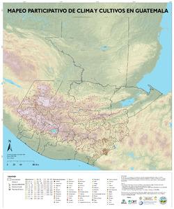
Navarro-Racines C, Sosa A, Chávez M, Zúñiga A, Gómez R. 2020. Mapeo Participativo de Clima y Cultivos en Guatemala. CGIAR Research Program on Climate Change, Agriculture and Food Security (CCAFS).